Mountain Huts around Kandersteg, Switzerland
Will Ross, July 30, 2017
Located in the north Bernese Alps in Switzerland, Kandersteg’s riverside location and modest 1200m elevation are just the beginning of story. A scattering of mountain huts sit above the village, offering formidable single-day treks with the option of shelter and sleep at the end of your hike up the hill.
For some orientation: Hiking routes from the Kander Valley connect with the neighbouring canton of Valais to the south via the Gemmi Pass (2314m), while the higher Lötschen Pass (2690m) loops over the Lötschental to the south-east. Kandersteg gives access to 550km of hiking trails – impressive considering the permanent population is little more than 1000 people.
Doldenhornhütte (1915m)

Sweeping through larch and pine forests, this mountain hut caps the treeline with broad views over Oeschinensee. Set out along the Oeschibach river, taking the road from the base of the cable car before using a path marked by white-red-white signs. A rocky ledge, “Bärentritt”, marks the upward route, secured by a safety wire before another crossing of a stream over a new bridge. Keep left at the fork to head up to Doldenhorn, remembering to note the junction and the alternative route for your descent.
5.3km, 750vm gain, 1914m max. elevation
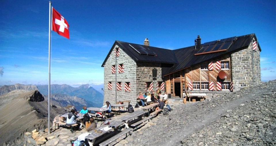
Blüemlisalphütte (2840m)
Setting out from Kandersteg train station, follow signs to Oeschinensee, a mountain lake at 1578m where you can grab food at Berhotel Oeschinensee or Berhaus am Oeschinensee. Continue on its northern bank, rising up higher to slice Underbärgli Oberbärgli and pursue the Hohtürli Pass which splits Kandersteg from Kiental at 2840m. Blüemlisalp mountain hut is a 5-minute walk above Hohtürli.
Catch the sunset from the hut and contemplate the Blüemlisalp range which reaches up to Wyssi Faru (3648m). The hut overlooks the Blüemlisalp glacier where there is a designated climbing wall. Another route to the hut leads up from Grieslap, located to the north-east of Blüemlisalp mountain hut. If you use this route for your return trip, aim for the Reichenbach train station to grab a ride back to Kandersteg.
10.25km, 1700vm gain, 2832m max. elevation
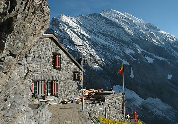
Fründenhütte (2562m)
Similar to Blüemlisalphütte, the route to Frudenhütte also flirts with Oeshinensee, instead slipping via its southern edge to hike up to the hut at 2562m.
9.4km, 1400vm gain, 2562m max. elevation
Mutthornhütte (2901m)

This glacier hike requires a small investment, the grabbing of a bus up the valley to Selden. From Selden, set out along the river Kander’s southern bank, passing through Heimritz and Schafgrinde to Kanderfirn. At Schafgrinde, look north for the blue-white signs that mark the entry to the glacier, using the rope-marked route to get you to the Mutthorn mountain hut.
12km, 1300vm gain, 2901m max. elevation
Balmhornhütte (1955m)
The Balmohorn mountain hut is at the foot of the Balmhorn (3698m) looking out above Gasterntal, one valley south from Kandersteg. The hike takes you through alpine meadows, passing via Waldhus where you can find Berghotel Waldhaus and refreshments.
8.2km, 817vm gain, 1959m max. elevation
Lämmerenhütte (2504m)
Located within a hunting ban area, the Lammeren mountain hut is near to a small lake within the glacial Wildstruble range and grazing grounds for ibex. Starting at Sunnbüel mountain station, follow the Gemmiweg trail along the western bank of Daubensee before taking a right along the river bank to Lämmeren. Find food at Bergrestaurant Sunnbüel and Berghotel Schwarenbach further up the hill.
12.75km, 736vm gain, 2506m max. elevation
Lötschenpasshütte (2690m)
Marking the divide between the Bern and Valais cantons, this route is best started in Selden from Hotel Steinbock. The first hour of hiking includes 300vm to Gfellalp (1845m), from where the trail pases through alpine meadows to Läckboden, a plateau and viewpoint into the sheer drops of the valley below. Hike up from the plateau through a further 250m of switcbacks to arrive at the pass and hut.
5.43km, 1192vm gain, 2689m max. elevation
Gspaltenhorn Mountain Hut (2458m)
Setting out from the Griesalp bus station, north-east of Kandersteg, route over the sub-terranean Gamchi glacier from Bundalp and Bundläger. The descent off the glacier involves a 20m rope ladder, so if you’re coming with a children or dogs, head up the route from the due north over the Gamchialp.
Equipment & Mapping
Grossen Sport rent hiking equipment if you’re missing any items. As for mapping, choose “Kandersteg and surroundings” which uses the scale 1:25,000 and can be purchased at the Kandersteg Tourist Office.
See more information on Kandersteg’s web of mountain huts and hiking routes at kandersteg.ch.